
HF026
Vegetation Patterns in Northeastern North America 1500-2000
Related PublicationsData
Overview
- Lead: Emily Russell
- Investigators:
- Contact: Information Manager
- Start date: 1500
- End date: 2000
- Status: complete
- Location: Northeastern North America
- Latitude: +38.0 to +47.5 degrees
- Longitude: -79.0 to -66.0 degrees
- Elevation:
- Datum: WGS84
- Taxa:
- Release date: 2023
- Language: English
- EML file: knb-lter-hfr.26.19
- DOI: digital object identifier
- EDI: data package
- DataONE: data package
- Related links:
- Study type: paleological
- Research topic: historical and retrospective studies; regional studies
- LTER core area: disturbance patterns, land use and land cover change, human-environment interactions
- Keywords: lakes, paleoecology, pollen, region, vegetation dynamics
- Abstract:
Over the last few centuries, human activities have changed the landscape of northeastern North America from mostly forested to a patchwork of forest, farmland and logged areas, back in many areas to mostly forested. Meanwhile, there have been many rapid changes in the composition of the remaining forests, for example, the amounts of hemlock (Tsuga canadensis) and beech (Fagus grandifolia) have decreased while the amount of birch (Betula spp.) has increased. How stable have been the basic vegetational patterns under the onslaught of these landscape and compositional changes? In preliminary analyses, the assemblages of major tree taxa have been zoned for every other century, using optimal splitting by information content and other techniques, to study changes in vegetation groupings over the last 500 years. Several patterns seem to be emerging on a centennial scale: First, vegetation patterns were changing in the centuries before European colonization of the area. Second, the number of zones (vegetation types, based on pollen), was greater in 1700 and 1900 than in 1500 or now. Third, the zone boundaries have moved north from 1500 to the present. Further analyses, including several more data sets will be used to refine these conclusions and to suggest explanations for the changes.
- Methods:
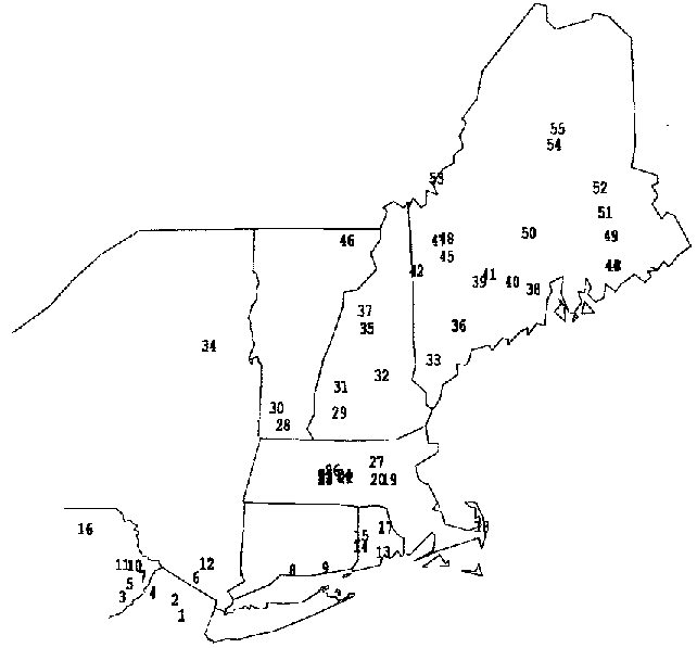
To study this question, a set of 52 pollen diagrams from lakes with detail in the last several centuries has been assembled for the northeastern United States.
- Organization: Harvard Forest. 324 North Main Street, Petersham, MA 01366, USA. Phone (978) 724-3302. Fax (978) 724-3595.
- Project: The Harvard Forest Long-Term Ecological Research (LTER) program examines ecological dynamics in the New England region resulting from natural disturbances, environmental change, and human impacts. (ROR).
- Funding: National Science Foundation LTER grants: DEB-8811764, DEB-9411975, DEB-0080592, DEB-0620443, DEB-1237491, DEB-1832210.
- Use: This dataset is released to the public under Creative Commons CC0 1.0 (No Rights Reserved). Please keep the dataset creators informed of any plans to use the dataset. Consultation with the original investigators is strongly encouraged. Publications and data products that make use of the dataset should include proper acknowledgement.
- License: Creative Commons Zero v1.0 Universal (CC0-1.0)
- Citation: Russell E. 2023. Vegetation Patterns in Northeastern North America 1500-2000. Harvard Forest Data Archive: HF026 (v.19). Environmental Data Initiative: https://doi.org/10.6073/pasta/5a4a0b97e159890b7d713d24a91d9452.
Detailed Metadata
hf026-01: list of lakes
- lake.name: lake name
- lake.number: lake number
- lat.deg.n: latitude (unit: degree / missing value: NA)
- lon.deg.w: longitude (unit: degree / missing value: NA)
- elevation: elevation (unit: meter / missing value: NA)
- data: data availability
- 1: in North American Pollen Database
- 2: submitted to North American Pollen Database
- 3: pending
- name: contact author
hf026-02: pollen
- name: name of lake or pond
- depth: depth in centimeters below the sediment surface (unit: centimeter / missing value: NA)
- pollen: pollen, using abbreviations used for North American Pollen Database
- count: numbers of grains counted (unit: number / missing value: NA)
hf026-03: map of lakes
- Compression: none
- Format: gif
- Type: image