
HF277
Tree Inventories for Validating Terrestrial Lidar Measurements at Harvard Forest 2007-2014
Related PublicationsData
- hf277-01: Harvard Forest hardwood tree inventory 2007 (preview)
- hf277-02: Harvard Forest hardwood tree inventory 2010 (preview)
- hf277-03: Harvard Forest hardwood inventory 2011 (preview)
- hf277-04: Harvard Forest hardwood inventory 2012 (preview)
- hf277-05: Harvard Forest hardwood inventory 2013 (preview)
- hf277-06: Harvard Forest hardwood tree inventory 2014 (preview)
- hf277-07: Harvard Forest hardwood plot layout
Overview
- Lead: Alan Strahler, Crystal Schaaf
- Investigators: Zhan Li, Ian Paynter
- Contact: Information Manager
- Start date: 2007
- End date: 2014
- Status: complete
- Location: Prospect Hill Tract (Harvard Forest)
- Latitude: +42.53075 to +42.53119 degrees
- Longitude: -72.18242 to -72.18169 degrees
- Elevation:
- Datum: WGS84
- Taxa:
- Release date: 2023
- Language: English
- EML file: knb-lter-hfr.277.6
- DOI: digital object identifier
- EDI: data package
- DataONE: data package
- Related links:
- Study type: long-term measurement
- Research topic: forest-atmosphere exchange; large experiments and permanent plot studies
- LTER core area: primary production, disturbance patterns
- Keywords: aboveground biomass, forest disturbance, inventories, lidar, tree maps
- Abstract:
Our objective is to improve the measurements of canopy structure and biomass of a forest stand and detect their annual changes via a ground-based laser scanning technology, also known as terrestrial lidar (TLS). A TLS instrument utilizes lasers to scan an environment, measure 3D locations of objects encountered by lasers and detect intensities of laser lights scattered by those objects back to the TLS instrument. TLS have shown abilities and is being further explored to retrieve stem diameter, stem count density, stand height, leaf area index, foliage profile, foliage area volume density, aboveground biomass and other useful forest structural parameters rapidly and accurately. Three TLS instruments used in this project include: (1) the Echidna (R) Validation Instrument (EVI), built by CSIRO Australia; (2) Dual-Wavelength Echidna® Lidar (DWEL), built by Boston University, University of Massachusetts, Lowell, University of Massachusetts, Boston and CSIRO Australia; (3) Compact Biomass Lidar (CBL), built by University of Massachusetts, Boston.
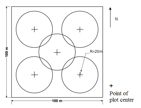
To validate the forest structural parameters retrieved using these TLS instruments, we set up a one-ha (100 m by 100 m) forest site and collected tree inventory data including: tree location, tree species, DBH, tree height and crown dimension since 2007 with a two-year gap of 2008 and 2009. Lidar data are available from the ORNL DAAC (http://dx.doi.org/10.3334/ORNLDAAC/1045).
- Methods:
In the Harvard Forest Hardwood site, our experimental design was to characterize a 100 m by 100 m square (1 ha) area of forest. The 1-ha site was divided into five plots, where the center of the plots located in the center point of the square and center points of four 50 m x 50 m squares nested within the site (see the figure of plot layout). True north compass readings were used to establish the square. The compass was corrected for magnetic declination. We laid out a circular plot around each center points with 20-m radius. At each plot, we numbered each tree and noted its species. We then recorded the distance from the plot center point to a tree using a laser rangefinder, the azimuth of the tree from the center point using a sighting compass (magnetic north; the compass used to measure the bearings was not corrected for magnetic declination), and the tree’s diameter (DBH) at breast height (1.3 m) using a diameter tape. We included all trees of DBH greater than 3 cm within 10 m of the plot center, and all trees of DBH greater than 10 cm beyond that distance. We also noted the extent to which each tree would be visible to a TLS instrument deployed at a plot center point while scanning by tallying it as visible, partly occluded by intervening trunks or foliage, or fully occluded.
In addition, we selected 10 individual trees, taken as the first tree at or beyond an azimuth increment of 36°, and measured the tree height, the height at which the crown began, and the crown diameter. The height of the tree was measured by a laser range finder, and the crown diameter was measured by a tape. The details of tree sampling for the measurements of tree height and crown dimension are as following:
(1) Set up the sample sectors. Divide the 360° azimuth range into 10 equal sectors, each of which is 36°.
(2) Sample 10 trees of whichever crown position but NOT dead. Select the first tree from the start azimuth of each sector, i.e. 0°, 36°, 72°, 108°, … 324°, totally 10 trees of whichever crown position but NOT dead. If there is no qualified tree in one sector, select one more tree in next sector. It means the first two trees in the next sector will be sampled.
(3) Add extra dominant trees so that 6 dominant trees are sampled in the study plot. (a) Find the number of extra dominant trees needed, N. (b) Choose N sectors evenly if N ≤ 5. If N = 6, create six unique random numbers between 1 and 10 with whatever tools (for example, in R using command sample(1:10, 6, replace=FALSE) ) and choose these 6 sectors. (c) Select the first dominant tree NOT dead from each of these N sectors.
- Organization: Harvard Forest. 324 North Main Street, Petersham, MA 01366, USA. Phone (978) 724-3302. Fax (978) 724-3595.
- Project: The Harvard Forest Long-Term Ecological Research (LTER) program examines ecological dynamics in the New England region resulting from natural disturbances, environmental change, and human impacts. (ROR).
- Funding: National Science Foundation LTER grants: DEB-8811764, DEB-9411975, DEB-0080592, DEB-0620443, DEB-1237491, DEB-1832210.
- Use: This dataset is released to the public under Creative Commons CC0 1.0 (No Rights Reserved). Please keep the dataset creators informed of any plans to use the dataset. Consultation with the original investigators is strongly encouraged. Publications and data products that make use of the dataset should include proper acknowledgement.
- License: Creative Commons Zero v1.0 Universal (CC0-1.0)
- Citation: Strahler A, Schaaf C. 2023. Tree Inventories for Validating Terrestrial Lidar Measurements at Harvard Forest 2007-2014. Harvard Forest Data Archive: HF277 (v.6). Environmental Data Initiative: https://doi.org/10.6073/pasta/4927df6c19983a911e156bc11bf10d2b.
Detailed Metadata
hf277-01: Harvard Forest hardwood tree inventory 2007
- date: date of the start of field campaign. The exact date of taking measurement could be one day later than this data.
- site: site name
- plot.id: plot identification
- subplot.id: circular plot location
- CP: center
- NE: northeast
- NW: northwest
- SE: southeast
- SW: southwest
- tree.no: tree identification number
- species: common name of species
- dbh: diameter at breast height (unit: centimeter / missing value: NA)
- distance: distance from the trunk surface of a tree to the plot center (unit: meter / missing value: NA)
- bearing: magnetic bearing of a tree with regard to the plot center (unit: degree / missing value: NA)
- tree.height: height of canopy top of selected trees (unit: meter / missing value: NA)
- crown.base: height of the base of the canopy of a tree, defined by the lowest live branch (unit: meter / missing value: NA)
- occl: occlusion status of a tree as seen from the plot
center
- V: visible
- O: occluded
- P: partially visible
- cr.p: crown position
- Dead: dead tree
- D: dominant
- C: co-dominant
- I: intermediate
- S: suppressed or overtopped
- radius1: half of crown diameter in the largest dimension (unit: meter / missing value: NA)
- radius2: half of crown diameter perpendicular to the largest dimension (unit: meter / missing value: NA)
- notes: field notes about the appearance of the tree, or the identification in another plot of common trees between two or more plots
hf277-02: Harvard Forest hardwood tree inventory 2010
- plot.id: site name and location of circular plot
- Harv_01_CP: Harvard Forest, center of circular plot
- Harv_01_NE: Harvard Forest, northeast
- Harv_01_NW: Harvard Forest, northwest
- Harv_01_SE: Harvard Forest, southeast
- Harv_01_SW: Harvard Forest, southwest
- tree.no: tree identification number
- bearing: magnetic bearing of a tree with regard to the plot center (unit: degree / missing value: NA)
- dist: distance from the trunk surface of a tree to the plot center (unit: meter / missing value: NA)
- dbh: diameter at breast height (unit: centimeter / missing value: NA)
- occl: occlusion status of a tree as seen from the plot
center
- V: visible
- O: occluded
- P: partially visible
- species: common name of species
- cr.p: crown position
- dead: dead tree
- D: dominant
- C: co-dominant
- I: intermediate
- S: suppressed or overtopped
- height: height of canopy top of selected trees (unit: meter / missing value: NA)
- h.cr: height of the base of the canopy of a tree, defined by the lowest live branch (unit: meter / missing value: NA)
- diameter1: crown diameter in the largest dimension (unit: meter / missing value: NA)
- diameter2: crown diameter perpendicular to the largest dimension (unit: meter / missing value: NA)
- notes: field notes about the appearance of the tree, or the identification in another plot of common trees between two or more plots
- date: date of the start of field campaign. The exact date of taking measurement could be one day later than this data.
hf277-03: Harvard Forest hardwood inventory 2011
- plot.id: site name and location of circular plot
- Harv_01_CP: Harvard Forest, center
- Harv_01_NE: Harvard Forest, northeast
- Harv_01_NW: Harvard Forest, northwest
- Harv_01_SE: Harvard Forest, southeast
- Harv_01_SW: Harvard Forest, southwest
- tree.no: tree identification number
- bearing: magnetic bearing of a tree with regard to the plot center (unit: degree / missing value: NA)
- dist: distance from the trunk surface of a tree to the plot center (unit: meter / missing value: NA)
- dbh: diameter at breast height (unit: centimeter / missing value: NA)
- occl: occlusion status of a tree as seen from the plot
center
- V: visible
- O: occluded
- P: partially visible
- species: common name of species
- cr.p: crown position
- Dead: dead tree
- D: dominant
- C: co-dominant
- I: intermediate
- S: suppressed or overtopped
- height: height of canopy top of selected trees (unit: meter / missing value: NA)
- h.cr: height of the base of the canopy of a tree, defined by the lowest live branch (unit: meter / missing value: NA)
- diameter1: crown diameter in the largest dimension (unit: meter / missing value: NA)
- diameter2: crown diameter perpendicular to the largest dimension (unit: meter / missing value: NA)
- notes: field notes about the appearance of the tree, or the identification in another plot of common trees between two or more plots
- date: date of the start of field campaign. The exact date of taking measurement could be one day later than this data.
hf277-04: Harvard Forest hardwood inventory 2012
- plot.id: site name and location of circular plot
- Harv_01_CP: Harvard Forest, center
- Harv_01_NE: Harvard Forest, northeast
- Harv_01_NW: Harvard Forest, northwest
- Harv_01_SE: Harvard Forest, southeast
- Harv_01_SW: Harvard Forest, southwest
- tree.no: tree indentification number
- bearing: magnetic bearing of a tree with regard to the plot center (unit: degree / missing value: NA)
- dist: distance from the trunk surface of a tree to the plot center (unit: meter / missing value: NA)
- dbh: diameter at breast height (unit: centimeter / missing value: NA)
- occl: occlusion status of a tree as seen from the plot
center
- V: visible
- O: occluded
- P: partially visible
- species: common name of species
- cr.p: crown position
- Dead: dead tree
- D: dominant
- C: co-dominant
- I: intermediate
- S: suppressed or overtopped
- height: height of canopy top of selected trees (unit: meter / missing value: NA)
- h.cr: height of the base of the canopy of a tree, defined by the lowest live branch (unit: meter / missing value: NA)
- diameter1: crown diameter in the largest dimension (unit: meter / missing value: NA)
- diameter2: crown diameter perpendicular to the largest dimension (unit: meter / missing value: NA)
- notes: field notes about the appearance of the tree, or the identification in another plot of common trees between two or more plots
- date: date of the start of field campaign. The exact date of taking measurement could be one day later than this data.
hf277-05: Harvard Forest hardwood inventory 2013
- plot.id: site name and location of circular plot
- Harv_01_CP: Harvard Forest, center
- Harv_01_NE: Harvard Forest, northeast
- Harv_01_NW: Harvard Forest, northwest
- Harv_01_SE: Harvard Forest, southeast
- Harv_01_SW: Harvard Forest, southwest
- tree.no: tree identification number
- bearing: magnetic bearing of a tree with regard to the plot center (unit: degree / missing value: NA)
- dist: distance from the trunk surface of a tree to the plot center (unit: meter / missing value: NA)
- dbh: diameter at breast height (unit: meter / missing value: NA)
- occl: occlusion status of a tree as seen from the plot
center
- V: visible
- O: occluded
- P: partially visible
- species: common name of species
- cr.p: crown position
- Dead: dead tree
- D: dominant
- C: co-dominant
- I: intermediate
- S: suppressed or overtopped
- height: height of canopy top of selected trees (unit: meter / missing value: NA)
- h.cr: height of the base of the canopy of a tree, defined by the lowest live branch (unit: meter / missing value: NA)
- diameter1: crown diameter in the largest dimension (unit: micrometer / missing value: NA)
- diameter2: crown diameter perpendicular to the largest dimension (unit: meter / missing value: NA)
- notes: field notes about the appearance of the tree, or the identification in another plot of common trees between two or more plots
- date: date of the start of field campaign. The exact date of taking measurement could be one day later than this data.
- tree.no.2012: tree identification number in 2012. From 2013, the tree numbers are different from 2012 and previous years. For those tree sampled for crown measurements, we identified them with their tree numbers in 2012.
hf277-06: Harvard Forest hardwood tree inventory 2014
- plot.id: site name and location of circular plot
- Harv_01_CP: Harvard Forest, center
- Harv_01_NE: Harvard Forest, northeast
- Harv_01_NW: Harvard Forest, northwest
- Harv_01_SE: Harvard Forest, southeast
- Harv_01_SW: Harvard Forest, southwest
- tree.no: tree identification number
- bearing: magnetic bearing of a tree with regard to the plot center (unit: degree / missing value: NA)
- dist: distance from the trunk surface of a tree to the plot center (unit: meter / missing value: NA)
- dbh: diameter at breast height (unit: centimeter / missing value: NA)
- occl: occlusion status of a tree as seen from the plot
center
- V: visible
- O: occluded
- P: partially visible
- species: common name of species
- cr.p: crown position
- Dead: dead tree
- D: dominant
- C: co-dominant
- I: intermediate
- S: suppressed or overtopped
- height: height of canopy top of selected trees (unit: meter / missing value: NA)
- h.cr: height of the base of the canopy of a tree, defined by the lowest live branch (unit: meter / missing value: NA)
- diameter1: crown diameter in the largest dimension (unit: meter / missing value: NA)
- diameter2: crown diameter perpendicular to the largest dimension (unit: meter / missing value: NA)
- notes: field notes about the appearance of the tree, or the identification in another plot of common trees between two or more plots
- date: date of the start of field campaign. The exact date of taking measurement could be one day later than this data.
- tree.no.2012: tree identification number in 2012. From 2013, the tree numbers are different from 2012 and previous years. For those tree sampled for crown measurements, we identified them with their tree numbers in 2012.
hf277-07: Harvard Forest hardwood plot layout
- Compression: none
- Format: png
- Type: image