
HF294
Landscape Phenology from Unmanned Aerial Vehicle Photography at Harvard Forest 2013
Related PublicationsData
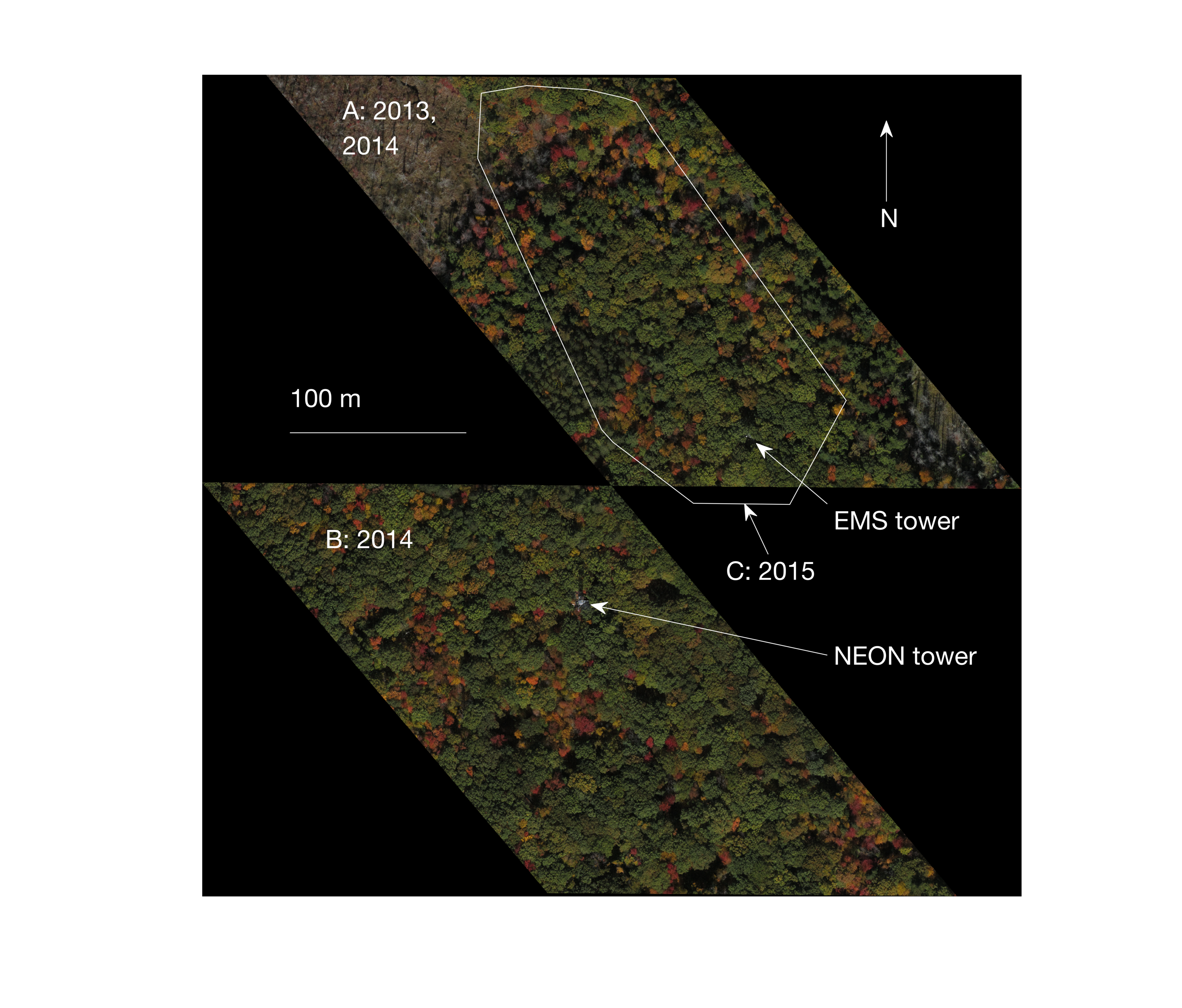
- hf294-01: site map
- hf294-02: site A 2013 orthophotos
- hf294-03: site A 2013 flight logs
- hf294-04: site A 2014 orthophotos
- hf294-05: site B 2014 orthophotos
- hf294-06: site C 2015 orthophotos
Overview
- Lead: Stephen Klosterman, Andrew Richardson
- Investigators:
- Contact: Information Manager
- Start date: 2013
- End date: 2013
- Status: complete
- Location: Prospect Hill Tract (Harvard Forest)
- Latitude: +42.5375 to +42.5396 degrees
- Longitude: -72.1749 to -72.1696 degrees
- Elevation: 337 to 348 meter
- Datum: WGS84
- Taxa:
- Release date: 2023
- Language: English
- EML file: knb-lter-hfr.294.6
- DOI: digital object identifier
- EDI: data package
- DataONE: data package
- Related links:
- Study type: short-term measurement
- Research topic: ecological informatics and modelling; physiological ecology, population dynamics and species interactions
- LTER core area: primary production
- Keywords: canopies, foliage, imagery, landscape, leaves, phenology, remote sensing
- Abstract:
This data set contains orthophotos in the vicinity of the EMS tower at Harvard Forest, as well as the flight logs from the unmanned aerial vehicle (UAV) used to obtain the digital images used in orthophoto creation. Orthophotos were created by mosaicking approximately 200 JPEG images from each date of observation. The orthophotos cover the spatial extent of the 250 meter resolution MODIS pixel that contains the EMS tower. Land cover types in the area of photography include deciduous and evergreen forest, and wetlands.
The research goal of data collection for this data set was to observe spatial variance in plant phenology. Therefore, photos were taken from before leaf out until after leaf drop. Orthophotos were collected approximately every 5 days during spring and weekly during fall; see filenames for specific dates.
The nominal spatial resolution of the orthophotos is 6 cm, however due to various factors including inaccuracy of the onboard GPS, wind-blown motion of trees, the automated orthophoto mosaicking process, and user error in final georeferencing, image analysis has been conducted at 10 m resolution. The orthophotos are available as GeoTIFF files.
- Methods:
We used a UAV (3DR ArduCopter Quad-C model) equipped with a digital camera (Canon Powershot A3300) to capture JPEG images continuously during flights. The UAV was programmed to cover the study area (250 m MODIS pixel) in two flights of approximately 10 minutes each. Orthophotos were created from the JPEGs and estimates of image locations, derived from the image file creation times and the UAV flight logs, using the PhotoScan software (AgiSoft, St. Petersburg, Russia). Final georeferencing was performed in ERDAS IMAGINE AutoSync (Intergraph, Huntsville, AL).
The log files contain many variables relating to UAV flight control. Of primary interest are the GPS logs, which are contained on the lines beginning with “GPS”. For further details on log files, see: http://ardupilot.org/copter/docs/common-downloading-and-analyzing-data-logs-in-mission-planner.html#.
Additional technical details are available in Klosterman, Stephen, Eli Melaas, Jon Wang, Arturo Martinez, Sidni Frederick, John O'Keefe, David Orwig, Zhuosen Wang, Qingsong Sun, Crystal Schaaf, Mark Friedl, Andrew D. Richardson. 2018. Fine-scale perspectives on landscape phenology from unmanned aerial vehicle (UAV) photography. Agricultural and Forest Meteorology v. 248 pp. 397-407.
- Organization: Harvard Forest. 324 North Main Street, Petersham, MA 01366, USA. Phone (978) 724-3302. Fax (978) 724-3595.
- Project: The Harvard Forest Long-Term Ecological Research (LTER) program examines ecological dynamics in the New England region resulting from natural disturbances, environmental change, and human impacts. (ROR).
- Funding: National Science Foundation LTER grants: DEB-8811764, DEB-9411975, DEB-0080592, DEB-0620443, DEB-1237491, DEB-1832210.
- Use: This dataset is released to the public under Creative Commons CC0 1.0 (No Rights Reserved). Please keep the dataset creators informed of any plans to use the dataset. Consultation with the original investigators is strongly encouraged. Publications and data products that make use of the dataset should include proper acknowledgement.
- License: Creative Commons Zero v1.0 Universal (CC0-1.0)
- Citation: Klosterman S, Richardson A. 2023. Landscape Phenology from Unmanned Aerial Vehicle Photography at Harvard Forest 2013. Harvard Forest Data Archive: HF294 (v.6). Environmental Data Initiative: https://doi.org/10.6073/pasta/0736191bf6a03ea8e4cede20f5ce6534.
Detailed Metadata
hf294-01: site map
- Compression: none
- Format: png
- Type: image
hf294-02: site A 2013 orthophotos
- Compression: zip
- Format: tiff
- Type: image
hf294-03: site A 2013 flight logs
- Compression: zip
- Format: text
- Type: document
hf294-04: site A 2014 orthophotos
- Compression: zip
- Format: tiff
- Type: image
hf294-05: site B 2014 orthophotos
- Compression: zip
- Format: tiff
- Type: image
hf294-06: site C 2015 orthophotos
- Compression: zip
- Format: tiff
- Type: image