
HF123
Canopy LiDAR Measurements in Hemlock Removal Experiment at Harvard Forest 2005
Related PublicationsData
Overview
- Lead: John Weishampel, Teresa Riedel
- Investigators:
- Contact: Information Manager
- Start date: 2005
- End date: 2005
- Status: complete
- Location: Simes Tract (Harvard Forest)
- Latitude: +42.47 to +42.48 degrees
- Longitude: -72.22 to -72.21 degrees
- Elevation: 200 to 240 meter
- Datum: WGS84
- Taxa:
- Release date: 2023
- Language: English
- EML file: knb-lter-hfr.123.14
- DOI: digital object identifier
- EDI: data package
- DataONE: data package
- Related links:
- Study type: short-term measurement
- Research topic: large experiments and permanent plot studies
- LTER core area: disturbance patterns
- Keywords: canopy cover, hemlock, hemlock woolly adelgid, management, remote sensing
- Abstract:
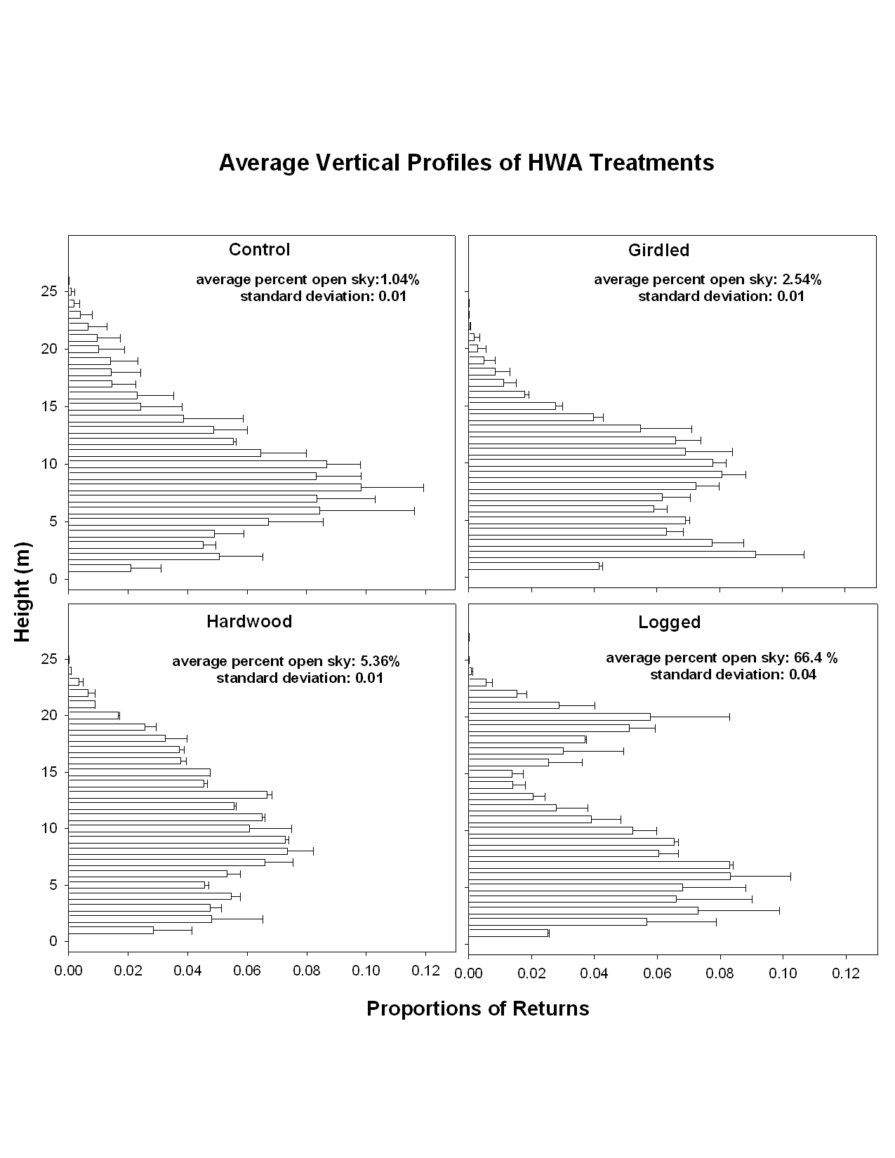
As the ecological functioning of a forest stand is often related to the spatial organization of the canopy, we used a portable canopy LiDAR (PCL; Parker et al. 2004) to measure volumetric canopy structure in the simulated HWA management treatments. In September and October 2005, prior to leaf abscission, we set up 16 parallel transects spaced 2 meters apart in the 900 m2 (30 x 30 m) interior of each of the eight treatment plots. The orientation of the transects were either north-south or east-west to minimize the difficulty of traversing the stand. The distances to canopy surfaces more than1 m above the ground along the transects were recorded with the PCL. Assuming a constant horizontal sampling rate, the continual height measures were binned into 1 m intervals. From these measures, vertical canopy profiles, canopy openness, canopy rugosity, and other metrics related to the three-dimensional structure of the canopy can be derived. These canopy measures will be repeated minimally at 5 and 15 year intervals to develop an understanding of early structural dynamics and micrometeorological consequences associated with the simulated HWA treatments. (Parker, G.G., D.J. Harding, and M.L. Berger. 2004. A portable LIDAR system for rapid determination of forest canopy structure. Journal of Applied Ecology 41, 755-767).
- Methods:
The LiDAR data file consists of returns binned to 1m along track intervals for the eight hemlock removal plots. Plot numbers and coordinates correspond to the hemlock removal plot conventions (see HF106). The number of returns for each plot varies as a function of the time it takes to traverse the transects.
- Organization: Harvard Forest. 324 North Main Street, Petersham, MA 01366, USA. Phone (978) 724-3302. Fax (978) 724-3595.
- Project: The Harvard Forest Long-Term Ecological Research (LTER) program examines ecological dynamics in the New England region resulting from natural disturbances, environmental change, and human impacts. (ROR).
- Funding: National Science Foundation LTER grants: DEB-8811764, DEB-9411975, DEB-0080592, DEB-0620443, DEB-1237491, DEB-1832210.
- Use: This dataset is released to the public under Creative Commons CC0 1.0 (No Rights Reserved). Please keep the dataset creators informed of any plans to use the dataset. Consultation with the original investigators is strongly encouraged. Publications and data products that make use of the dataset should include proper acknowledgement.
- License: Creative Commons Zero v1.0 Universal (CC0-1.0)
- Citation: Weishampel J, Riedel T. 2023. Canopy LiDAR Measurements in Hemlock Removal Experiment at Harvard Forest 2005. Harvard Forest Data Archive: HF123 (v.14). Environmental Data Initiative: https://doi.org/10.6073/pasta/aefd890c600efa3736c0d13d7c365b57.
Detailed Metadata
hf123-01: LiDAR measurements
- plot: plot number
- x: location of return in west-east direction (unit: meter / missing value: NA)
- y: location of return in south-north direction (unit: meter / missing value: NA)
- z: range from PCL (open sky, i.e. no return, is designated as “NA”) (unit: meter / missing value: NA)
- r: amount of pulse return (open sky, i.e. no return, is designated as “NA”) (unit: number / missing value: NA)
hf123-02: average vertical profiles of HWA treatment
- Compression: none
- Format: jpeg
- Type: image