
HF070
Prospect Hill Hydrological Stations at Harvard Forest since 2005
Related PublicationsData
- hf070-01: station log (preview)
- hf070-02: manual (preview)
- hf070-03: daily (preview)
- hf070-04: 15-minute (preview)
Overview
- Lead: Emery Boose, Mark VanScoy
- Investigators: Paul Barten, Elizabeth Colburn, William Sobczak
- Contact: Information Manager
- Start date: 2005
- End date: 2025
- Status: ongoing. Data updated monthly
- Location: Prospect Hill Tract (Harvard Forest)
- Latitude: +42.53 to +42.55 degrees
- Longitude: -72.20 to -72.17 degrees
- Elevation: 280 to 420 meter
- Datum: WGS84
- Taxa:
- Release date: 2026
- Language: English
- EML file: knb-lter-hfr.70.37
- DOI: digital object identifier
- EDI: data package
- DataONE: data package
- Related links:
- Real-Time Measurements
- Site Map
- Photos
- Fisher Meteorological Station at Harvard Forest since 2001
- Harvard Forest Snow Pillow since 2009
- Study type: long-term measurement
- Research topic: watershed ecology
- LTER core area: mineral cycling, disturbance patterns
- Keywords: hydrology, stream discharge, water balance, water temperature, wetlands
- Abstract:
To better understand the critical role of headwater streams and wetlands in our forest ecosystem, long-term measurements were initiated in 2005 on two small watersheds in the Prospect Hill Tract of the Harvard Forest. On Nelson Brook, weirs were installed on outlet streams of an 11-ha spruce-hemlock wetland (watershed area = 44 ha). On Arthur Brook (formerly Bigelow Brook), pipes were installed to measure flow above (watershed = 24 ha) and below (watershed = 65 ha) a 3-ha shrub-dominated beaver swamp. The gaged watersheds, though adjacent and comparable in size, differ significantly in topography, soils, wetlands, stream chemistry, stream biota, land-use history, and forest vegetation, and provide an extraordinary opportunity to study the impacts of these factors on small watershed hydrology and ecology.
Weekly manual measurements were initiated in April 2005. Continuous automated measurements were initiated at the stream gages in December 2007 and at the wetland gages in October 2008. Data for the current month are available online, updated every 15 minutes, with out-of-range values replaced by NA but values not otherwise checked. Earlier data are checked and archived monthly with missing, questionable, and estimated values flagged, following methods of the LTER ClimbDB project. A log of events affecting station measurements is also posted.
For current data, please see: https://harvardforest.fas.harvard.edu/met-hydro-stations.
- Methods:
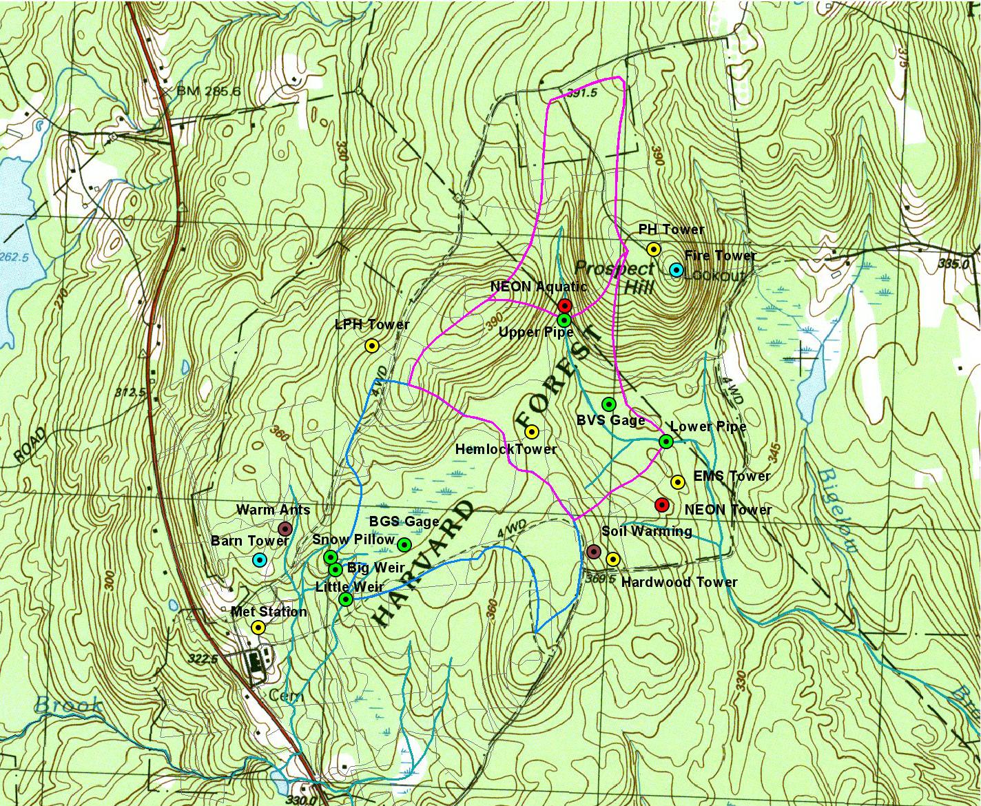
Experimental Design
See online map for locations of gages and watershed boundaries. Note that the two Nelson Brook gages measure discharge from the same watershed (parallel outlets), while the Arthur Brook gages measure discharge from nested watersheds. Nelson Brook flows northwest to the Millers River and Connecticut River. Arthur Brook flows southeast to the Swift River, Quabbin Reservoir, Chicopee River, and Connecticut River.
Nelson Brook Big Weir (NB). 120-degree V-notch weir with rectangular spillway. V-notch height = 10 in (25.4 cm). Spillway width = 13 ft (3.96 m). Watershed area = 44 ha. Gage location = 42.53478 N, 72.18655 W.
Nelson Brook Little Weir (NL). 120-degree V-notch weir with rectangular spillway. V-notch height = 4 in (10.2 cm). Spillway width = 5 ft (1.52 m). Watershed area = 44 ha. Gage location = 42.53363 N, 72.18602 W.
Arthur Brook Lower Pipe (AL). Corrugated polyethylene pipe with smooth interior. Diameter = 30 in (76.2 cm). Length = 16 ft (4.88 m). Slope = 0.01087. Manning coefficient = 0.012. Watershed area = 65 ha. Gage location = 42.53909 N, 72.17213 W.
Arthur Brook Upper Pipe (AU). Corrugated polyethylene pipe with smooth interior. Diameter = 24 in (61.0 cm). Length = 10 ft (3.05 m). Slope = 0.01969. Manning coefficient = 0.012. Watershed area = 24 ha. Gage location = 42.54295 N, 72.17659 W.
Black Gum Swamp (BGS). Nelson Brook watershed. Wetland area = 11 ha. Gage location = 42.53527 N, 72.18398 W.
Beaver Swamp (BVS). Arthur Brook watershed. Wetland area = 3 ha. Gage location = 42.54032 N, 72.17445 W.
Manual Measurements
Water levels at the weirs were measured with metal rulers attached to the weirs (values relative to the notch). Water levels inside pipes were measured with ruler and chalk 40 cm from the downstream end. Water levels in the BGS and BVS wetlands were originally measured in an existing well (relative to the soil surface) and at an existing gage (relative to 3.28 feet), respectively. In fall 2008 new gages for automated measurements were installed at new locations in each wetland. The Arthur Brook Lower Pipe was replaced on 16-Oct-2006. Before that date, the pipe was corrugated steel with a partial asphalt liner, diameter = 36 in (91.4 cm), length = 16 ft (4.88 m), slope = 0.01087, manning coefficient = 0.019.
Automated Measurements
Water level: Pressure transducers have included Druck 1830 2.5 psig, Campbell 450, and Keller America Acculevel SDI-12 models. Water temperature: Campbell 107 temperature probes. At weir sites, instruments are mounted on steel brackets attached to the weirs. At pipe sites, instruments are mounted in wells 30 cm below the bottom of the stream channel and 1 m upstream from the pipe intake. At wetland sites, instruments are mounted on vertical pipes 60 cm below average water level. At each site a permanent manual gage may be used to check instrument readings. Instruments are scanned every 10 seconds and 15-minute average values are retained. All times are Eastern Standard Time.
Data analysis
Stream discharge is calculated from water level (stage) using standard flow equations. At pipe sites, water depth in the pipe is estimated from measured stage using empirical rating curves. Daily values are calculated from 15-minute measurements. Data are checked and posted with missing, questionable, and estimated values flagged, following methods of the LTER ClimDB project. A log of events affecting station measurements is also posted.
Ice effects
In very cold weather, ice damming may result in artificially high stage and discharge values. If ice damming is prolonged, daily values may be adjusted and marked as estimated and a note added to the log. 15-minute values are not adjusted.
Operational notes
Gages are not heated. Ice is removed regularly in winter to ensure proper flow through the gages. At Nelson Little Weir, the pressure transducer is removed in mid-winter to prevent ice damage and discharge is modeled from measured flow at Nelson Big Weir.
- Organization: Harvard Forest. 324 North Main Street, Petersham, MA 01366, USA. Phone (978) 724-3302. Fax (978) 724-3595.
- Project: The Harvard Forest Long-Term Ecological Research (LTER) program examines ecological dynamics in the New England region resulting from natural disturbances, environmental change, and human impacts. (ROR).
- Funding: National Science Foundation LTER grants: DEB-8811764, DEB-9411975, DEB-0080592, DEB-0620443, DEB-1237491, DEB-1832210.
- Use: This dataset is released to the public under Creative Commons CC0 1.0 (No Rights Reserved). Please keep the dataset creators informed of any plans to use the dataset. Consultation with the original investigators is strongly encouraged. Publications and data products that make use of the dataset should include proper acknowledgement.
- License: Creative Commons Zero v1.0 Universal (CC0-1.0)
- Citation: Boose E, VanScoy M. 2026. Prospect Hill Hydrological Stations at Harvard Forest since 2005. Harvard Forest Data Archive: HF070 (v.37). Environmental Data Initiative: https://doi.org/10.6073/pasta/7a9228945ad4837a24d8782f46f4d924.
Detailed Metadata
hf070-01: station log
- date: date
- notes: notes on station maintenance, repairs, and other issues affecting measurements
hf070-02: manual
- date: date
- nb.time: Julian day and fraction of a day (unit: nominalDay / missing value: NA)
- nb.stg: measured stage at Nelson Big Weir (unit: centimeter / missing value: NA)
- nb.dis: calculated discharge at Nelson Big Weir (unit: litersPerSecond / missing value: NA)
- nl.time: Julian day and fraction of a day (unit: nominalDay / missing value: NA)
- nl.stg: measured stage at Nelson Little Weir (unit: centimeter / missing value: NA)
- nl.dis: calculated discharge at Nelson Little Weir (unit: litersPerSecond / missing value: NA)
- al.time: Julian day and fraction of a day (unit: nominalDay / missing value: NA)
- al.stg: measured stage at Arthur Lower Pipe (unit: centimeter / missing value: NA)
- al.dis: calculated discharge Arthur Lower Pipe (unit: litersPerSecond / missing value: NA)
- au.time: Julian day and fraction of a day (unit: nominalDay / missing value: NA)
- au.stg: measured stage at Arthur Upper Pipe (unit: centimeter / missing value: NA)
- au.dis: calculated discharge at Arthur Upper Pipe (unit: litersPerSecond / missing value: NA)
- bgs.time: Julian day and fraction of a day (unit: nominalDay / missing value: NA)
- bgs.stg: measured stage at Black Gum Swamp (unit: centimeter / missing value: NA)
- bvs.time: Julian day and fraction of a day (unit: nominalDay / missing value: NA)
- bvs.stg: measured stage at Beaver Swamp (unit: centimeter / missing value: NA)
hf070-03: daily
- date: date
- jd: Julian day (unit: nominalDay )
- nt.dis: total discharge from Nelson Weirs (unit: litersPerSecond / missing value: NA)
- f.nt.dis: flag for nt.dis
- E: Missing. Instrument not installed, instrument not working correctly, or measured value out of range.
- M: Estimated. Value estimated from incomplete measurements or from other sources.
- al.dis: discharge from Arthur Lower Pipe (unit: litersPerSecond / missing value: NA)
- f.al.dis: flag for al.dis
- M: Missing. Instrument not installed, instrument not working correctly, or measured value out of range.
- E: Estimated. Value estimated from incomplete measurements or from other sources.
- au.dis: discharge from Arthur Upper Pipe (unit: litersPerSecond / missing value: NA)
- f.au.dis: flag for au.dis
- M: Missing. Instrument not installed, instrument not working correctly, or measured value out of range.
- E: Estimated. Value estimated from incomplete measurements or from other sources.
- nb.wt: water temperature at Nelson Big Weir (unit: celsius / missing value: NA)
- f.nb.wt: flag for nb.wt
- M: Missing. Instrument not installed, instrument not working correctly, or measured value out of range.
- E: Estimated. Value estimated from incomplete measurements or from other sources.
- al.wt: water temperature at Arthur Lower Pipe (unit: celsius / missing value: NA)
- f.al.wt: flag for al.wt
- M: Missing. Instrument not installed, instrument not working correctly, or measured value out of range.
- E: Estimated. Value estimated from incomplete measurements or from other sources.
- au.wt: water temperature at Arthur Upper Pipe (unit: celsius / missing value: NA)
- f.au.wt: flag for au.wt
- M: Missing. Instrument not installed, instrument not working correctly, or measured value out of range.
- E: Estimated. Value estimated from incomplete measurements or from other sources.
hf070-04: 15-minute
- datetime: date and time at end of sampling period
- jd: Julian day (unit: nominalDay )
- nb.stg: stage at Nelson Big Weir (unit: centimeter / missing value: NA)
- f.nb.stg: flag for nb.stg
- M: Missing. Instrument not installed, instrument not working correctly, or measured value out of range.
- E: Estimated. Value estimated from incomplete measurements or from other sources.
- nl.stg: stage at Nelson Little Weir (unit: centimeter / missing value: NA)
- f.nl.stg: flag for nl.stg
- M: Missing. Instrument not installed, instrument not working correctly, or measured value out of range.
- E: Estimated. Value estimated from incomplete measurements or from other sources.
- al.stg: stage at Arthur Lower Pipe (unit: centimeter / missing value: NA)
- f.al.stg: flag for al.stg
- M: Missing. Instrument not installed, instrument not working correctly, or measured value out of range.
- E: Estimated. Value estimated from incomplete measurements or from other sources.
- au.stg: stage at Arthur Upper Pipe (unit: centimeter / missing value: NA)
- f.au.stg: flag for au.stg
- M: Missing. Instrument not installed, instrument not working correctly, or measured value out of range.
- E: Estimated. Value estimated from incomplete measurements or from other sources.
- bgs.stg: stage at Black Gum Swamp (unit: centimeter / missing value: NA)
- f.bgs.stg: flag for bgs.stg
- M: Missing. Instrument not installed, instrument not working correctly, or measured value out of range.
- E: Estimated. Value estimated from incomplete measurements or from other sources.
- bvs.stg: stage at Beaver Swamp (unit: centimeter / missing value: NA)
- f.bvs.stg: flag for bvs.stg
- M: Missing. Instrument not installed, instrument not working correctly, or measured value out of range.
- E: Estimated. Value estimated from incomplete measurements or from other sources.
- nb.dis: discharge at Nelson Big Weir (unit: litersPerSecond / missing value: NA)
- f.nb.dis: flag for nb.dis
- M: Missing. Instrument not installed, instrument not working correctly, or measured value out of range.
- E: Estimated. Value estimated from incomplete measurements or from other sources.
- nl.dis: discharge at Nelson Little Weir (unit: litersPerSecond / missing value: NA)
- f.nl.dis: flag for nl.dis
- M: Missing. Instrument not installed, instrument not working correctly, or measured value out of range.
- E: Estimated. Value estimated from incomplete measurements or from other sources.
- nt.dis: total discharge from Nelson Weirs (unit: litersPerSecond / missing value: NA)
- f.nt.dis: flag for nt.dis
- M: Missing. Instrument not installed, instrument not working correctly, or measured value out of range.
- E: Estimated. Value estimated from incomplete measurements or from other sources.
- al.dis: discharge from Arthur Lower Pipe (unit: litersPerSecond / missing value: NA)
- f.al.dis: flag for al.dis
- M: Missing. Instrument not installed, instrument not working correctly, or measured value out of range.
- E: Estimated. Value estimated from incomplete measurements or from other sources.
- au.dis: discharge from Arthur Upper Pipe (unit: litersPerSecond / missing value: NA)
- f.au.dis: flag for au.dis
- M: Missing. Instrument not installed, instrument not working correctly, or measured value out of range.
- E: Estimated. Value estimated from incomplete measurements or from other sources.
- nb.wt: water temperature at Nelson Big Weir (unit: celsius / missing value: NA)
- f.nb.wt: flag for nb.wt
- M: Missing. Instrument not installed, instrument not working correctly, or measured value out of range.
- E: Estimated. Value estimated from incomplete measurements or from other sources.
- nl.wt: water temperature at Nelson Little Weir (unit: celsius / missing value: NA)
- f.nl.wt: flag for nl.wt
- M: Missing. Instrument not installed, instrument not working correctly, or measured value out of range.
- E: Estimated. Value estimated from incomplete measurements or from other sources.
- al.wt: water temperature at Arthur Lower Pipe (unit: celsius / missing value: NA)
- f.al.wt: flag for al.wt
- M: Missing. Instrument not installed, instrument not working correctly, or measured value out of range.
- E: Estimated. Value estimated from incomplete measurements or from other sources.
- au.wt: water temperature at Arthur Upper Pipe (unit: celsius / missing value: NA)
- f.au.wt: flag for au.wt
- M: Missing. Instrument not installed, instrument not working correctly, or measured value out of range.
- E: Estimated. Value estimated from incomplete measurements or from other sources.
- bgs.wt: water temperature at Black Gum Swamp (unit: celsius / missing value: NA)
- f.bgs.wt: flag for bgs.wt
- M: Missing. Instrument not installed, instrument not working correctly, or measured value out of range.
- E: Estimated. Value estimated from incomplete measurements or from other sources.
- bvs.wt: water temperature at Beaver Swamp (unit: celsius / missing value: NA)
- f.bvs.wt: flag for bvs.wt
- M: Missing. Instrument not installed, instrument not working correctly, or measured value out of range.
- E: Estimated. Value estimated from incomplete measurements or from other sources.